The data are publicly available and can already be used for planning and monitoring urban development.
Researchers from the Technical University of Munich (TUM) have presented the GlobalBuildingAtlas – the world's first detailed three-dimensional map of all buildings on the planet. The project covers literally the entire built surface of the Earth, and it is already being called a key tool for climate research and the implementation of the United Nations' sustainable development goals. The new data allow for more accurate modeling of urbanization processes, infrastructure development, and disaster risk management, thus making cities more resilient and livable.
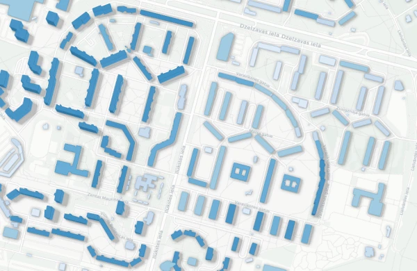
How many buildings exist on Earth and what do they look like in three dimensions? This question was answered by a team led by Professor Xiaoxian Zhu, head of the Data Science in Earth Observation department at TUM. The project was implemented with the support of the ERC Starting Grant – a major European scientific grant allocated for the launch of breakthrough research. As a result, the GlobalBuildingAtlas was created, which includes 2.75 billion building models. The dataset contains all structures recorded by satellite images in 2019. This makes it the most comprehensive global catalog of its kind. In comparison, the largest previous global dataset contained about 1.7 billion buildings.
The uniqueness of the atlas lies not only in its scale but also in its detail. The spatial resolution of the models is 3×3 meters, which is approximately 30 times more accurate than comparable global databases. In other words, the data allow for a much clearer view of the actual volume of construction, rather than just its outlines on a map.
At the same time, 97 percent of all buildings, which is about 2.68 billion objects, are represented in LoD1 format. This refers to a simplified level of three-dimensional detail that conveys the basic shape of a building and its height. Such models do not show architectural details, but they are easily scalable and suitable for calculations. They can be used for analyzing urban structure, estimating construction volumes, and planning infrastructure. An important distinction of the GlobalBuildingAtlas from previous projects is its geography. It includes regions that have often remained "white spots" on global maps, including countries in Africa, South America, and rural areas.
As Professor Zhu emphasizes, three-dimensional information about buildings provides a much more accurate representation of urbanization and living standards than traditional two-dimensional maps. "With the help of 3D models, we see not only the area of construction but also the volume of each building. This allows for a much more accurate assessment of living conditions," he notes.
As part of the project, scientists also proposed a new global indicator. This is the volume of buildings per person. This indicator reflects the total mass of residential and infrastructure construction relative to the population. Essentially, it helps to reveal social and economic disparities between regions that are not always visible on ordinary maps. According to Zhu, such an indicator can make cities more inclusive and resilient to future challenges.
The data from the GlobalBuildingAtlas are publicly available and can already be used for planning and monitoring urban development. They allow for more accurate identification of where there is a shortage of housing, schools, or medical facilities, and for making targeted decisions in overcrowded and socially vulnerable areas.
The role of this data in climate change adaptation is equally important. Three-dimensional information about construction improves models of energy consumption and carbon dioxide emissions, as well as helps in planning green infrastructure. Furthermore, it significantly simplifies risk assessment in the event of natural disasters. Potential damage from floods or earthquakes can be analyzed more quickly and accurately based on actual building volumes rather than abstract outlines.
Interest in the project is already extending beyond the academic environment. The German Aerospace Center (DLR) is exploring the possibilities of using the GlobalBuildingAtlas within the framework of the "International Charter: Space and Major Disasters" initiative, which utilizes satellite data for emergency response worldwide.
The Technical University of Munich hopes that the GlobalBuildingAtlas will become a fundamental tool for researchers, urban authorities, and international organizations, helping to make more informed decisions in a rapidly changing world.