
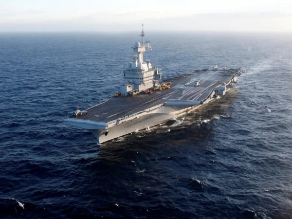
A French serviceman revealed the exact location of the aircraft carrier "Charles de Gaulle" using the sports activity tracking app "Strava," reports the newspaper "Le Monde," citing LETA referring to AFP.
France's flagship "Charles de Gaulle" with accompanying frigates was deployed in the Mediterranean Sea in early March after U.S. and Israeli strikes on Iran led to military conflict in the Middle East.
The aircraft carrier has been in the southern part of the Mediterranean since March 9. French President Emmanuel Macron described this as a "purely defensive" position to support France's allies in the conflict.
According to "Le Monde," a public profile on the "Strava" app shows that on March 13, a user was running in circles on a ship that was moving at sea northwest of Cyprus. Satellite images indicate that the aircraft carrier was nearby at that time.
The same individual was running in late February in Copenhagen on the bridge from the Swedish city of Malmö, where the "Charles de Gaulle" was docked at the time, according to "Strava" data.
The French Armed Forces confirmed to AFP that if the information is accurate, appropriate measures will be taken, as naval personnel are regularly reminded of the security risks associated with using such apps.
"The reported incident — if confirmed — does not comply with current instructions," the military stated.
Earlier, profiles in such apps had already become sources of leaks of confidential information.
In 2024, "Le Monde" reported that the bodyguards of French President Emmanuel Macron, U.S. President Joe Biden, and Russian leader Vladimir Putin, while accompanying them on trips, accidentally revealed data about their locations.
In 2018, "Strava" maps showed the locations of U.S. military personnel and their allies in Iraq, Syria, and Afghanistan.
While some bases were well known to groups that could plan attacks, the maps also showed routes that military personnel likely used when moving outside the bases, and such information could be used for planning explosions or ambushes.


Leave a comment