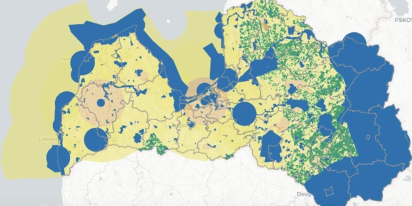
The map of industrial areas developed by the Ministry of Climate and Energy (MCE) will allow residents to gain a general understanding of the situation, but currently does not provide detailed and accurate information about the possibilities for the development of wind farms (WF), note wind farm developers, reports LETA.
Ilva Boreiko, the development director of Latvenergo, noted in a conversation with the agency that the ministry, together with the Latvian Environment, Geology and Meteorology Centre (LEGMC), has created a digital map that is useful for the general public, where everyone can familiarize themselves with the potential opportunities for wind energy development.
"In our opinion, the map will give residents a general idea of whether there is an opportunity to develop wind farms on their land. However, it should be noted that the map may create a false impression that construction of wind farms is possible in areas where there are no restrictions," Boreiko stated, adding that Latvenergo's experience shows that even in areas where construction is theoretically allowed, detailed analysis reveals that in 50–70% of cases, it turns out to be impossible.
According to her, the map is convenient for initial familiarization by the general public, but it is not suitable for professional use due to the lack of several features — for example, there is no scaling, and distances cannot be measured. As a positive aspect, Boreiko highlighted the availability of data sources and the ability to upload necessary information layers.
Baiba Zaure, head of the Latvian office of the renewable energy project developer Vindr, emphasized that the map should provide an initial understanding of locations in Latvia where the implementation of wind farm projects is possible or restricted.
"As can be seen, there is no reason to believe that the entire territory of Latvia will be developed with wind, solar, or hydro energy facilities in the future. However, the map also confirms that there are sufficient potential areas in Latvia for wind farm projects," Zaure stated.
According to her, the map is a positive step that the ministry aims to make the selection of areas for wind farms more transparent. It can serve as a guideline for understanding whether such construction is generally permissible in a specific zone; however, its practical value directly depends on the regular updating of data.
"For example, deforestation, especially clear-cutting, can significantly affect the state of biotopes and bird protection issues. Without updates, the map can quickly lose accuracy," Zaure noted, adding that the information about current environmental impact assessment (EIA) processes reflected on the map is incomplete. The question of the quality of the data included in it is already relevant.
Zaure emphasized that the development of wind energy is of strategic importance for Latvia — wind farms can be built relatively quickly, which will allow for an increase in electricity production within the country in the coming years and strengthen energy security and predictability. She noted that the map is a step towards more transparent planning and public discussions.
As previously reported, the Ministry of Climate and Energy (MCE), in collaboration with LEGMC, has developed a map of industrial areas, which will serve as the basis for the next stage — consultations with the industry, non-governmental organizations, and social partners.
The map is the first step towards targeted and balanced planning of industrial development in Latvia. This tool is being created for the first time and combines information about potential locations for production facilities, infrastructure projects, including those for energy generation from renewable resources. The mapping of territories is conducted to develop a common understanding of where it is most effective and feasible to develop production and entrepreneurship.
The prepared map is not a final decision but an informational tool that will be used for planning industrial development areas, discussions with the public, local governments, and in the preparation of sectoral policy documents. Its goal is to ensure transparent, data-driven decision-making regarding the development of specific territories. At the same time, the tool will be useful for residents — it will provide an opportunity to familiarize themselves in detail with the real situation and development prospects in their region.
Different information layers from various sources were used to create the maps. Data on restrictions established by Latvian legislation (for example, from the Nature Conservation Agency, the Ministry of Defense, and local governments) as well as zones regulated by EU norms are included. The data was supplemented in collaboration with information holders from various institutions.
The information layers of the map are divided into two groups — restrictions and challenges (for example, densely populated areas, radar zones, protected natural areas, inventoried forests, and nationally significant agricultural lands) and informational (for example, data on peat resources, information from the Rural Register, declared plots by farmers, as well as public and residential buildings within a radius of 800 meters).
MCE plans to organize individual online consultations with stakeholders regarding the content of the initial version of the map in November and December.
The proposed map can be viewed at: meteo.lv/teritorijuriks.